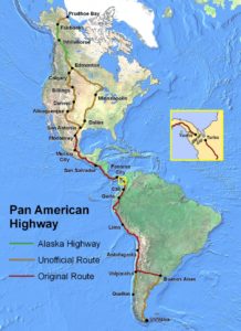
To appreciate the Darién, you need to see it in a larger context. The Pan-American Highway is a series of interconnected roads that form passage from northern Alaska to the southern tip of South America, a distance of about 19,000 miles. It is continuous, except for an approximately 100-mile break in the dense jungle of the Darién province in eastern Panama—The Darién Gap. Here, the highway ends in Yaviza, Panama, and does not resume again until Turbo, Colombia. For various social, political, environmental, and engineering reasons, this stretch of highway was never built, and there are currently no plans to do so.

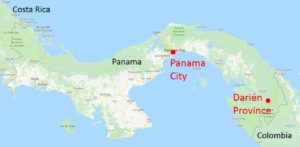
We tend to think of Panama as a north-south country lying at the intersection of Central and South Americas; however, in reality, the country is more of an S-shape laying on its side, running east and west. It’s trademark feature, the Panama Canal, effectively runs north and south. In our case, we started in the capital, Panama City, in the center of the country and traveled to its easternmost province, Darién, near the Colombian border.
To get to the Darién, we left Panama City at 5 am on a 7-hour bus ride to the small town of Yaviza, marking the end of the highway. At this point, land travel ends and most transportation is by boat on the Darién’s vast network of rivers and streams. In our case, we traveled by boat along the Chucunaque River to its confluence with the Tuira, where we headed east for a few kilometers until disembarking at the small town of El Real de Santa Maria. El Real has a few paved streets and a handful of pickup trucks operate as taxis, transporting passengers from the boat dock to the town, and in our case also along a gravel road about 10 miles to the Emberá Indian village of Pijibasal.
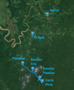
Pijibasal offers one of two trailheads entering this part of the Darién National Park. Within the park, travel is on foot, winding along trails of variable quality and increasingly difficult terrain as you climb your way up one of the main peaks in the Pirre mountain range, known as Cerro Pirre (Mount Pirre), elevation 1,150 meters (3,770 feet). It took us a day and a half to climb the mountain and I was able to track our course using a handheld Garmin GPS. Afterwards, I plotted our trail on a geo-referenced contour map, allowing an appreciation of the increasingly difficulty of the climb as we made our way up the mountain.
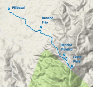
After months of planning, it was a pleasure to visit these places and define their locations, as many don’t appear on maps and we weren’t entirely certain where we were going before.
